


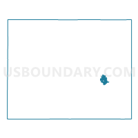
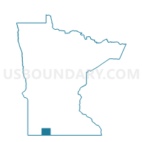
Jackson W-1 P-1, Jackson County, Minnesota
About
Outline

Summary
| Unique Area Identifier | 602666 |
| Name | Jackson W-1 P-1 |
| County | Jackson County |
| State | Minnesota |
| Area (square miles) | 2.35 |
| Land Area (square miles) | 2.35 |
| Water Area (square miles) | 0.00 |
| % of Land Area | 100.00 |
| % of Water Area | 0.00 |
| Latitude of the Internal Point | 43.63812640 |
| Longtitude of the Internal Point | -94.98720060 |
Maps

Graphs
Select a template below for downloading or customizing gragh for Jackson W-1 P-1, Jackson County, Minnesota


Neighbors
Neighoring Voting District (by Name) Neighboring Voting District on the Map
- Des Moines Twp. Voting District, Jackson County, MN
- Jackson W-1 P-2, Jackson County, MN
- Jackson W-2 P-1, Jackson County, MN
- Wisconsin Twp. Voting District, Jackson County, MN
Top 10 Neighboring County Subdivision (by Population) Neighboring County Subdivision on the Map
- Jackson city, Jackson County, MN (3,299)
- Wisconsin township, Jackson County, MN (233)
- Des Moines township, Jackson County, MN (232)